| Title | Google Earth |
| Version | Varies with device |
| Price | Free |
| Category | Common |
| Package | com.google.earth |
Google Earth is Google's powerful and free application that puts the entire planet at your fingertips. Whether you are a curious traveler dreaming of far-off places, an educator bringing geography to life in the classroom, or simply someone who wants to see your own neighborhood from a satellite's perspective, Google Earth offers an immersive and interactive 3D map of the world. With high-resolution satellite imagery, detailed terrain, 3D buildings, and seamless Street View integration, you can explore virtually any location on Earth from the comfort of your device. The app is designed to be intuitive and accessible, making it easy for anyone to zoom from space down to street level, discover new places, and even dive into guided tours created by experts. Download Google Earth and start your journey of discovery today.
Key Features
- Stunning Satellite Imagery and 3D Terrain – Explore a vast collection of high-resolution satellite images covering the entire globe. Zoom in to see natural landscapes, urban centers, and remote areas in incredible detail. The 3D terrain rendering brings mountains, valleys, and canyons to life, giving you a realistic sense of elevation and geography.
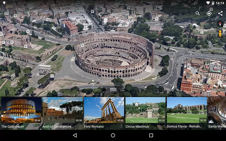
- Immersive 3D Buildings and Street View – Many major cities and landmarks are reconstructed in 3D, allowing you to fly around skyscrapers, monuments, and historic sites. With a simple tap, you can drop into Street View and explore streets, parks, and plazas as if you were walking there yourself.
- Voyager – Guided Tours and Stories – Voyager is a curated collection of interactive tours, geospatial stories, and educational content created by scientists, storytellers, and cultural institutions. You can take a virtual trip to the Amazon rainforest, follow the migration of whales, or explore ancient ruins – all with rich multimedia narratives.
- Measure Distances and Areas – Use the built-in measuring tool to calculate straight-line distances or draw paths and polygons to measure the area of any region. This feature is handy for trip planning, real estate research, or satisfying your curiosity about the size of landmarks.
- Create and Share Custom Projects – Build your own maps by adding placemarks, lines, shapes, and image overlays. You can save your projects to Google Drive and share them with friends, family, or colleagues. This is an excellent tool for storytelling, classroom assignments, or planning an itinerary.
- Historical Imagery and TimeLapse – Slide through time to see how a location has changed over decades. Google Earth offers historical satellite and aerial imagery for many regions. The TimeLapse feature shows the transformation of our planet from space, revealing urban growth, deforestation, melting glaciers, and more.
- Seamless Integration with Google Services – Sign in with your Google account to access your saved places, search history, and custom maps across devices. You can also easily switch between Google Earth and Google Maps for directions, local business info, and real-time traffic.
Why Choose Google Earth?
Google Earth stands out as more than just a map app – it is a gateway to understanding our planet in ways that were once unimaginable. Unlike traditional maps, Google Earth provides a true 3D environment where you can tilt, rotate, and fly from space down to street level, giving you a sense of scale and perspective that static maps cannot match. The depth of content is staggering: from the highest peaks of the Himalayas to the deepest points of the ocean, from bustling city streets to the quiet solitude of the Sahara, every corner of the Earth is available to explore at your own pace.
For educators and students, Google Earth is an invaluable tool for geography, history, environmental science, and more. The Voyager feature offers ready-made lessons and interactive journeys that make learning engaging and visual. For travelers, it is the perfect companion for pre-trip reconnaissance – you can virtually walk through a neighborhood, check the terrain of a hiking trail, or see if your hotel has an ocean view. Even if you never leave your home, Google Earth can inspire wonder and connect you with cultures, landscapes, and natural phenomena you may never have known existed.
How to Use Google Earth
Getting started with Google Earth is simple. After downloading the app, you will be greeted with a rotating view of the globe. You can search for any location using the search bar, or simply use your finger to pan, pinch to zoom, and tilt the map by dragging with two fingers. To fly to a location, type an address, landmark, or coordinates – Google Earth will zoom in smoothly from space. If you want to see Street View imagery, look for the Pegman icon (a small yellow figure) in the corner of the map, then drag him onto any blue-highlighted road to drop into street-level exploration.
To take full advantage of Google Earth, try exploring the Voyager section by tapping the ship’s wheel icon on the toolbar. Choose from thousands of curated trips and quizzes. You can also create your own map by tapping the “Projects” icon. Add placemarks by dropping a pin, draw lines to trace a route, and even import images or YouTube videos to enrich your presentation. Once your project is ready, share it with a link or export it as a KML file for use in other mapping tools. For a deeper understanding of how our planet changes over time, enable the “Historical Imagery” button (a clock icon) to scroll through available past images. The TimeLapse feature can be accessed from the menu to watch global transformations from 1984 to the present day.
Tips and Tricks for an Enhanced Experience
To get the most out of Google Earth, try these simple tips. If you want faster loading times, make sure you are connected to Wi-Fi, especially when loading high-resolution imagery. Use the “I’m Feeling Lucky” button on the home screen to be teleported to a random interesting location – perfect for spontaneous discovery. When exploring 3D buildings, you can adjust the tilt angle by pinching two fingers and dragging up or down, giving you a realistic flyover perspective. For measuring precise distances, tap the ruler icon and select your unit of measurement – you can even measure in miles, kilometers, or feet. If you are using Google Earth for trip planning, create a project with all your points of interest, then share it with your travel companions so everyone has the same map.
Another useful feature is the “Knowledge Cards” that pop up when you tap on famous landmarks or points of interest. These cards provide quick facts, Wikipedia links, and related photos. You can also enable the “Grid” view to see latitude and longitude lines, which is helpful for geography enthusiasts. If you are interested in space, use the “Toggle Sidebar” button to access the “Explore” menu and choose “Sky” – this lets you view stars, constellations, and other celestial bodies. While this is a separate experience, it shows the breadth of what Google Earth offers.
Google Earth is constantly being updated with new imagery, features, and educational content. It is available for free on Android devices and works offline for certain areas if you download maps in advance. Whether you are planning a real-world adventure, teaching a lesson, or simply satisfying your curiosity about the world, Google Earth is the most comprehensive and engaging way to explore our planet. Download the app today and see the world from a perspective you never imagined.